Despite widespread connectivity, critical gaps remain in reaching vulnerable populations during emergencies. The national coverage statistics show that 173 million people worldwide
(ITU Facts and Figures 2025) live in areas not covered by early warning messages. Understanding where people can be reached is essential for effective disaster response. To address this need,
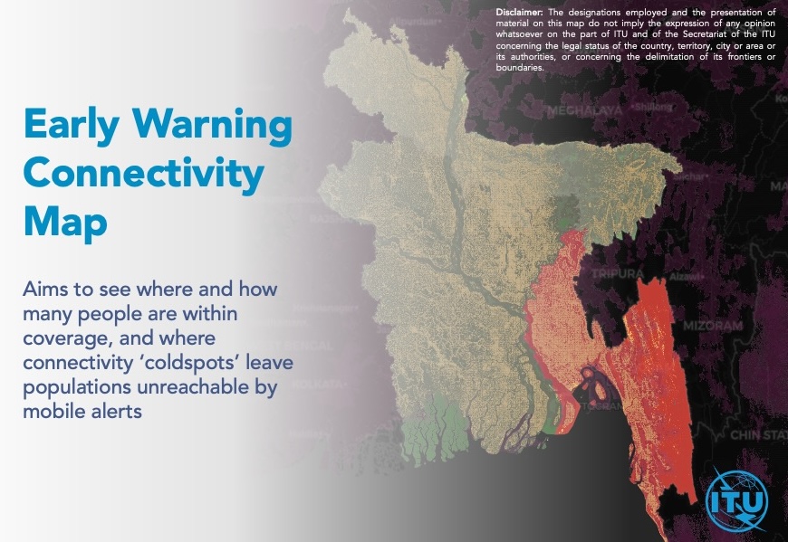
the International Telecommunication Union (ITU) has developed the Early Warning Connectivity Map (EWCM).
What does EWCM do?
The EWCM overlays high-resolution
population,
network coverage and connectivity, and
hazard exposure datasets to generate granular subnational maps and datasets that show where people are located, whether they are connected, and whether they are exposed to hazards.
In the context of the
Early Warnings for All initiative, this tool identifies the populations that are unable to receive emergency alerts in high-risk areas due to limited or no network coverage, supporting governments in designing tailored dissemination strategies and prioritizing infrastructure investments in underserved regions.
Where does the data come from?
In collaboration with Microsoft AI for Good Lab, the Institute for Health Metrics and Evaluation (IHME) at the University of Washington, and Planet Labs, the EWCM integrates high-resolution satellite imagery, AI-derived population density data, and multiple network coverage and connectivity datasets (building on the Disaster Connectivity Map) to locate and quantify connectivity gaps at 100-metre resolution.
These sources include the ITU Transmission Map, GSMA and Collins Bartholomew Ltd cellular coverage maps, regulators, MNOs, OpenCelliD, Meta for Good, Measurement Lab (M-Lab), NetBravo, Ookla for Good, and Speedchecker.
The historic coverage data has been, enriched with near real-time, crowd-sourced connectivity data to ensure accuracy. In addition, the infrastructure and coverage data has been discussed and validated by ITU Member States.
Country example
Liberia
|
Under Early Warnings for All, the EWCM has been completed as part of the connectivity assessment for effective cell broadcast in Liberia. The map's data provide information on places where people cannot receive early warning alert, especially those exposed to medium- and high-risk floods. These data are relevant for the government efforts in improving resilience and expanding network coverage. The image on the left shows data as of January 2026. Mobile network coverage is critically needed in Belleh, Kongba, Bopolu, Gounwolaila and Gbarma. These areas appear to have more people living in places beyond the reach of cellular networks, those who remain "offline."
More about the EWCM use case in Liberia in this AI for Good Webinar: |
Disclaimer
A number of ground truth tests have been carried out to compare results to connectivity levels observed on the ground, including by first responders. The connectivity levels, availability and gaps displayed in the map reflect the availability of these data sources and may in certain cases not provide the full connectivity picture. To further improve the quality and reliability of the map, engagement is ongoing with different partners to identify new data sources and AI applications.
Member States, Mobile Network Operators, and partners are invited to review, validate, and help improve the results.