Page 137 - Reference framework for integrated management of an SSC - A U4SSC deliverable on city platforms
P. 137

•  Interoperability
            •  Services

            •  Support

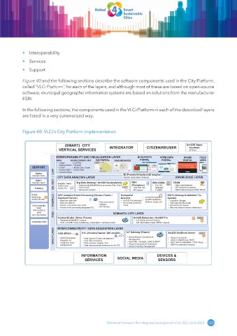
            Figure 40 and the following sections describe the software components used in the City Platform,
            called “VLCi Platform”, for each of the layers, and although most of these are based on open-source
            software, municipal geographic information systems are based on solutions from the manufacturer
            ESRI.


            In the following sections, the components used in the VLCi Platform in each of the described layers
            are listed in a very summarized way.


            Figure 40: VLCi’s City Platform implementation


                                  (SMART)  CITY                                                ArcGIS Apps
                               VERTICAL SERVICES        INTEGRATOR         CITIZEN/REUSER      - StoryMaps
                                                                                               - 3D Visor
                              INTEROPERABILITY AND VISUALIZATION LAYER  BI REPORTS   OPEN DATA  SHARE  FIELD
                             APIs    DEVELOPER’s KIT  GIS PORTAL  DASHBOARDS  PORTAL  PORTAL   PORTAL  APPS
                              • CKAN  • ECLIPSE
                              • NGSIv2 REST• TALEND
                 SUPPORT      • SOAP  • JBOSS Dev. Studio
                              • ArcGIS REST • ArcGIS SDK
                   Deploy   |   LDAP  • ArcGIS Python
                 DevOps Team  CITY DATA ANALYSIS LAYER         BI (Pentaho/Urbo/ArcGIS Insights)  KNOWLEDGE LAYER
                                                               Reports. Exploratory Analysis
                            SAFETY LAYER                IPSEC   |   FIREWALLS   |   SSL CERT
                   Admin
                 DevOps Team  Analytic Tools  Big Data (Hadoop / ArcGIS GeoAnalytics)   BDA   BDA (GDB)  CKAN
                                                                                        • Open data Datasets
                                                                   (Postgress)
                                        • Analysis with Map&Reduce processes (Pig, Oozie)
                                                                              •
                                                                               Esri GIS
                              Numpy Sci
                  Ticketing   Python Libs:   • HUE & HIVE           • Info SQL info  •  database  • API (import & consume)
                                                                                        • Data Catalog Support (W3C DCAT)
                                                                               PostGIS
                                        • Geospatial analysis
                                                                    • BI Support
                 Nagios       CEP Complex Event Processing (Perseo, Fiware /   Geospatial  HDFS (Hadoop Distributed File
                 Monitoring   GeoEvent Server)                Analysis   •  ArcGIS Enterprise  System)
                 ArcGIS Monitor  • Real time data flow  • Real time spatial  •  ArcGIS Pro (desktop)  •  ArcGIS Notebooks   • Long-term Storage
                                                                          (Python, Arcpy y R)
                                                   analysis
                                                               Tools
                                                                                      • Distributed file System
                               • Pattern associated rules motor
                 Environments.   • Minimum latence  • GIS fencing  •  ML & Deep Learning  • High Capacity (Big Data)
                   SaaS:       • Perseo event processing language EPL                 • Data redundance (Nodos distribution)
                  PRE & PRO &
                    INTE
                 Over OpenStack  Context Broker (Orion, Fiware)  SEMANTIC CITY LAYER
                                                                    ArcGIS Enterprise / ArcGIS Pro
                               • Standard NGSI REST Layouts
                                                                     GIS Server (ArcGIS Server)
                                                                    •
                 COMMUNICATIONS  INTERCONNECTIVITY / DATA ADQUISITION LAYER   IoT Gateway (Fiware)  ArcGIS GeoEvent Server
                                                                    •
                               • PULL & PUSH context publishing / subscription / retrieval modes
                                                                     GIS Information model / REST Layouts
                                          ETL (Pentaho/Talend / DIE ArcGIS)
                              ESB (WSO2)
                               • WSO2 Enterprise
                                                                  Management
                                                                                       JSON in WebSocket, REST
                               Integrator for
                                           • Over 450 connectors
                                                                 • SensorML, Ultralight, JSON & MQTT
                                                                                       RSS, MQTT, RabbitMQ, GTFS, Waze, …
                               integration flows
                                           • Work Creation Graphic Tool
                                                                 • Plugin developement Framework
                                                                                       SDK for customized sensors
                               management  • Data Source & chain management  • Device/Sensor Connection &   • • • •  Sensor connection
                                           • Data Interoperability Extension for ArcGIS
                                                                 • Device inventory management
                                          INFORMATION                           DEVICES &
                                            SERVICES        SOCIAL MEDIA        SENSORS
                                                       Reference framework for integrated management of an SSC | June 2023  123
   132   133   134   135   136   137   138   139   140   141   142