
Page 87 - Kaleidoscope Academic Conference Proceedings 2022
P. 87
Extended reality – How to boost quality of experience and interoperability
Start The ARN and LR modules were implemented using three
activities namely the Map activity, AR activity and landmark
activity in Android Studio. Map activity displays the user’s
Obtain accelerometer readings current location on a map and allows the user to select a
destination point to where they need AR directions. The AR
activity displays the AR turning point of objects during
Perform magnitude thresholding navigation. The landmark activity allows the user to point
their phone at an unknown landmark and displays its details
Perform temporal filtering in AR. The SDE module was implemented using the
accelerometer reading of the user to estimate their position
in the absence of GPS. The AR activity and the SDE activity
Obtain step count are interconnected to implement the hybrid approach of user
localization. Some screenshots of the implemented Android
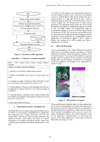
Foot stride application are illustrated in figures 5 and 6. Figure 5
displays the working of the ARN module and Figure 6
illustrates the LR module.
Determine distance traveled
4.1 ARN and LR modules
End The two main parameters for testing AR-based navigational
applications are locational accuracy and latency of object
Figure 4 – Flowchart of SDE algorithm generation and latency. The first parameter is mainly crucial
for the LR module. The testing for the landmark recognition
Algorithm 2 - Landmark recognition algorithm module involved validation of the location received from
Google Maps and the location calculated by the landmark
recognition algorithm. The findings of our experiments are
Input – User’s height, User’s current location, Phone’s shown in Table 1.
azimuth
Output – Location of pointed landmark
1. Initialize accelerometer, magnetometer sensors
2. Obtain the landmark view from the camera upon user
action
3. Calculate the angle of inclination (tilt) of the phone using
the accelerometer and magnetometer sensors [12]
4. Find the distance of the base of the landmark from the user
by applying the tangent function to the height and angle of
inclination
5. Using the distance, azimuth, and the current location, find
the latitude and longitude of the landmark using the inverse
Haversine formula [13].
Figure 5 – ARN module screenshots
6. Return the landmark location
The second parameter being the latency of object appearance
4. IMPLEMENTATION AND RESULTS on the user’s screen depends on the following three factors:
the framework used for rendering AR objects, complexity of
The MAR-PNS was developed using Android Studio (Arctic the algorithm used for localization of object position, and the
Fox 2020.3.1) [15], Google Cloud Platform [16] and Beyond device specific functionalities such as processor speed. The
AR Framework [17]. Google Directions API [18] and major contribution of latency lies in the framework chosen
Google Places API [19] are used for getting directions and for the application. Experimentally it is found that the
details of locations. Each module was tested on Android latency of AR object appearance is in the range of 60ms to
smartphones in an urban environment and the results were 80ms with an average of 74 ms.
validated against the physical locations and distances in real
time.
– 41 –