
Page 83 - Kaleidoscope Academic Conference Proceedings 2022
P. 83
ENHANCING USER EXPERIENCE IN PEDESTRIAN NAVIGATION BASED ON
AUGMENTED REALITY AND LANDMARK RECOGNITION
1
Dhananjay Kumar ; Shreayaas Iyer ; Easwar Raja ; Ragul Kumar ; Ved P. Kafle 2
1
1
1
1 Department of Information Technology, Anna University, MIT Campus, Chennai, India
2 National Institute of Information and Communications Technology, Tokyo, Japan
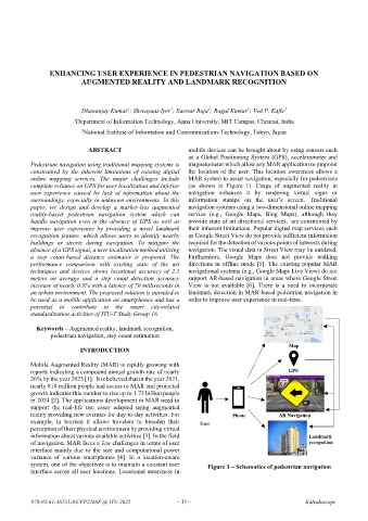
ABSTRACT mobile devices can be brought about by using sensors such
as a Global Positioning System (GPS), accelerometer and
Pedestrian navigation using traditional mapping systems is magnetometer which allow any MAR application to pinpoint
constrained by the inherent limitations of existing digital the location of the user. This location awareness allows a
online mapping services. The major challenges include MAR system to assist navigation, especially for pedestrians
complete reliance on GPS for user localization and inferior (as shown in Figure 1). Usage of augmented reality in
user experience caused by lack of information about the navigation enhances it by rendering virtual signs or
surroundings, especially in unknown environments. In this information stamps on the user’s screen. Traditional
paper, we design and develop a marker-less augmented navigation systems using a two-dimensional online mapping
reality-based pedestrian navigation system which can service (e.g., Google Maps, Bing Maps), although they
handle navigation even in the absence of GPS as well as provide state of art directional services, are constrained by
improve user experience by providing a novel landmark their inherent limitations. Popular digital map services such
recognition feature, which allows users to identify nearby as Google Street View do not provide sufficient information
buildings or streets during navigation. To mitigate the required for the detection of various points of interests during
absence of a GPS signal, a user localization method utilizing navigation. The visual data in Street View may be outdated.
a step count-based distance estimator is proposed. The Furthermore, Google Maps does not provide walking
performance comparison with existing state of the art directions in offline mode [5]. The existing popular MAR
techniques and devices shows locational accuracy of 2.5 navigational systems (e.g., Google Maps Live View) do not
meters on average and a step count detection accuracy support AR-based navigation in areas where Google Street
increase of nearly 0.5% with a latency of 70 milliseconds in View is not available [6]. There is a need to incorporate
an urban environment. The proposed solution is intended to landmark detection in MAR-based pedestrian navigation in
be used as a mobile application on smartphones and has a order to improve user experience in real-time.
potential to contribute to the smart city-related
standardization activities of ITU-T Study Group 16.
Keywords – Augmented reality, landmark recognition,
pedestrian navigation, step count estimation
Map
INTRODUCTION
Mobile Augmented Reality (MAR) is rapidly growing with
reports indicating a compound annual growth rate of nearly GPS
26% by the year 2025 [1]. It is believed that in the year 2021,
nearly 810 million people had access to MAR and projected
growth indicates this number to rise up to 1.73 billion people
in 2024 [2]. The applications development in MAR need to
support the real-life use cases adapted using augmented
reality providing new avenues for day-to-day activities. For Phone AR Navigation
example, in tourism it allows travelers to broaden their User
perception of their physical environment by providing virtual
information about various available activities [3]. In the field Landmark
of navigation, MAR faces a few challenges in terms of user recognition
interface mainly due to the size and computational power
variance of various smartphones [4]. In a location-aware
system, one of the objectives is to maintain a constant user Figure 1 – Schematics of pedestrian navigation
interface across all user locations. Locational awareness in
978-92-61-36151-8/CFP2268P @ ITU 2022 – 37 – Kaleidoscope