
Page 680 - Shaping smarter and more sustainable cities - Striving for sustainable development goals
P. 680
Technical guidance for
resources and toponym fusion
Service for resources Position adding for
and toponym fusion observation resources
Technical specification for resource
and toponym fusion in smart city
Application Electric Image data Flood event
Sensing node Transporta- sensor
tion sensor
node
Fire event
Processing Laser point
clouds
node
Management for resources Position correction for
and toponym fusion observation resources
Quality supervision for
resources and toponym fusion
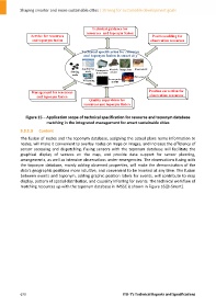
Figure 15 – Application scope of technical specification for resource and toponym database
matching in the integrated management for smart sustainable cities
3.3.1.3 Content
The fusion of nodes and the toponym database, assigning the actual place name information to
nodes, will make it convenient to overlay nodes on maps or images, and increase the efficiency of
sensor accessing and dispatching. Fusing sensors with the toponym database will facilitate the
graphical display of sensors on the map, and provide data support for sensor planning,
arrangements, as well as intensive observations under emergencies. The observations fusing with
the toponym database, mainly adding observed properties, will make the demonstration of the
data's geographic positions more intuitive, and convenient to be invoked at any time. The fusion
between events and toponym, adding graphic position labels for events, will contribute to map
display, pattern of spatial distribution, and causality inferring for events. The technical workflow of
matching resources up with the toponym database in IMSSC is shown in Figure 16 [b‐Smart].
670 ITU‐T's Technical Reports and Specifications