
Page 32 - Citiverse Use Case Taxonomy Overview - Use Case Identification Track
P. 32
Urban Planning Place Making and Infrastructure
Horizon
2
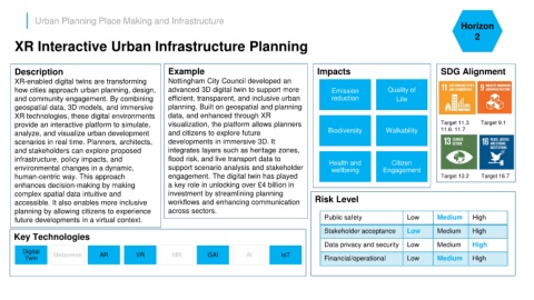
XR Interactive Urban Infrastructure Planning
Description Example Impacts SDG Alignment
XR-enabled digital twins are transforming Nottingham City Council developed an
how cities approach urban planning, design, advanced 3D digital twin to support more Emission Quality of
and community engagement. By combining efficient, transparent, and inclusive urban reduction Life
geospatial data, 3D models, and immersive planning. Built on geospatial and planning
XR technologies, these digital environments data, and enhanced through XR
provide an interactive platform to simulate, visualization, the platform allows planners Target 11.3 Target 9.1
analyze, and visualize urban development and citizens to explore future Biodiversity Walkability 11.6. 11.7
scenarios in real time. Planners, architects, developments in immersive 3D. It
and stakeholders can explore proposed integrates layers such as heritage zones,
infrastructure, policy impacts, and flood risk, and live transport data to Health and Citizen
environmental changes in a dynamic, support scenario analysis and stakeholder wellbeing Engagement
human-centric way. This approach engagement. The digital twin has played Target 13.2 Target 16.7
enhances decision-making by making a key role in unlocking over £4 billion in
complex spatial data intuitive and investment by streamlining planning
accessible. It also enables more inclusive workflows and enhancing communication Risk Level
planning by allowing citizens to experience across sectors.
future developments in a virtual context. Public safety Low Medium High
Stakeholder acceptance Low Medium High
Key Technologies
Data privacy and security Low Medium High
Digital Metaverse AR VR MR GAI AI IoT
Twin Financial/operational Low Medium High