
Page 80 - U4SSC KPIs Verification Manual - A guide for verifiers
P. 80
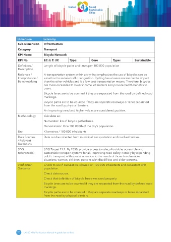
Dimension         Economy
              Sub-Dimension     Infrastructure

              Category          Transport
              KPI Name          Bicycle Network
              KPI No.           EC: I: T: 3C      Type:          Core           Type:          Sustainable

              Definition /      Length of bicycle paths and lanes per 100 000 population
              Description

              Rationale /       A transportation system within a city that emphasizes the use of bicycles can be
              Interpretation /   a method to reduce traffic congestion. Cycling has a lower environmental impact
              Benchmarking      than the other vehicles and is a low-cost transportation means. Therefore, bicycles
                                are more accessible to lower income inhabitants and provide health benefits to
                                users.
                                Bicycle lanes are to be counted if they are separated from the road by defined road
                                markings.

                                Bicycle paths are to be counted if they are separate roadways or lanes separated
                                from the road by physical barriers.
                                An improving trend and higher values are considered positive.

              Methodology       Calculate as:
                                Numerator: km of bicycle paths/lanes.
                                Denominator: One 100 000th of the city’s population.
              Unit              Kilometres / 100 000 inhabitants

              Data Sources      Data can be collected from municipal transportation and road authorities.
              / Relevant
              Databases
              SDG               SDG Target 11.2: By 2030, provide access to safe, affordable, accessible and
              Reference(s)      sustainable transport systems for all, improving road safety, notably by expanding
                                public transport, with special attention to the needs of those in vulnerable
                                situations, women, children, persons with disabilities and older persons.
             Verification       Check to see if calculation is based on 100 000 inhabitants and consistent with
             Guidance           population.

                                Check data source.
                                Check that definition of bicycle lanes was used properly.
                                Bicycle lanes are to be counted if they are separated from the road by defined road
                                markings.

                                Bicycle paths are to be counted if they are separate roadways or lanes separated
                                from the road by physical barriers.


             70  U4SSC KPIs Verification Manual-A guide for verifiers