
Page 71 - Citiverse Use Case Taxonomy Overview - Use Case Identification Track
P. 71
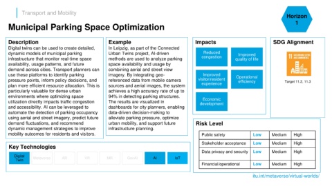
Transport and Mobility
                                                                                                                                                                       Horizon

      Municipal Parking Space Optimization                                                                                                                                  1


      Description                                               Example                                           Impacts                                      SDG Alignment
      Digital twins can be used to create detailed,             In Leipzig, as part of the Connected
      dynamic models of municipal parking                       Urban Twins project, AI-driven                         Reduced             Improved
      infrastructure that monitor real-time space               methods are used to analyze parking                   congestion         quality of life
      availability, usage patterns, and future                  space availability and usage by
      demand across cities. Transport planners can              combining aerial and street view
      use these platforms to identify parking                   imagery. By integrating geo-                          Improved            Operational
      pressure points, inform policy decisions, and             referenced data from mobile camera                  visitor/resident       efficiency                 Target 11.2, 11.3
      plan more efficient resource allocation. This is          sources and aerial images, the system                 experience
      particularly valuable for dense urban                     achieves a high accuracy rate of up to
      environments where optimizing space                       94% in detecting parking structures.
                                                                                                                      Economic
      utilization directly impacts traffic congestion           The results are visualized in                        development
      and accessibility. AI can be leveraged to                 dashboards for city planners, enabling
      automate the detection of parking occupancy               data-driven decision-making to
      using aerial and street imagery, predict future           alleviate parking pressure, optimize
      demand fluctuations, and recommend                        urban mobility, and support future                Risk Level
      dynamic management strategies to improve                  infrastructure planning.
      mobility outcomes for residents and visitors.                                                                   Public safety                Low        Medium       High

                                                                                                                      Stakeholder acceptance       Low        Medium       High
      Key Technologies
                                                                                                                      Data privacy and security    Low        Medium       High
         Digital
          Twin      Metaverse        AR           VR           MR          GenAI          AI          IoT
                                                                                                                      Financial/operational        Low        Medium       High


                                                                                                                                                   itu.int/metaverse/virtual-worlds/