
Page 68 - Citiverse Use Case Taxonomy Overview - Use Case Identification Track
P. 68
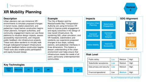
Transport and Mobility
                                                                                                                                                                       Horizon

      XR Mobility Planning                                                                                                                                                  2


      Description                                               Example                                           Impacts                                      SDG Alignment
      Urban planners can use immersive XR                       The City of Boston and the
      environments to simulate proposed changes                 Massachusetts Bay Transportation                   Inclusive Urban       Stakeholder
      in transit routes, station placement, and                 Authority are using immersive VR                       Planning          Engagement
      pedestrian impact before construction begins.             tools to improve public engagement
      Urban planners, transport authorities, and                and equity outcomes in the design of
      community engagement teams can use these                  new transit infrastructure. By                        Improved             Increased                    Target 16.7
      platforms to visualize design impacts, assess             combining GIS, urban simulation, and                Urban Design            Transit
      accessibility improvements, and integrate                 VR headsets, stakeholders and                                              Adoption
      public feedback into infrastructure projects.             residents can experience proposed
      These tools allow residents to virtually walk             changes to bus stops, subway
                                                                                                                                           Improved
      through redesigned transport infrastructure               stations, and pedestrian interfaces in              Active Mobility      Accessibility
      and give feedback before construction begins.             three dimensions. This fosters a
      These tools also enable public participation              deeper understanding of the urban                                                                     Target 11.2, 11.3
      and equity-focused design.                                environment and helps ensure that
                                                                infrastructure meets the needs of all             Risk Level
                                                                users, particularly underrepresented
                                                                communities.                                          Public safety                Low        Medium       High

                                                                                                                      Stakeholder acceptance       Low        Medium       High
      Key Technologies
                                                                                                                      Data privacy and security    Low        Medium       High
         Digital
          Twin      Metaverse        AR           VR           MR           GAI           AI          IoT
                                                                                                                      Financial/operational        Low        Medium       High


                                                                                                                                                   itu.int/metaverse/virtual-worlds/