
Early Warning Connectivity Map (EWCM)
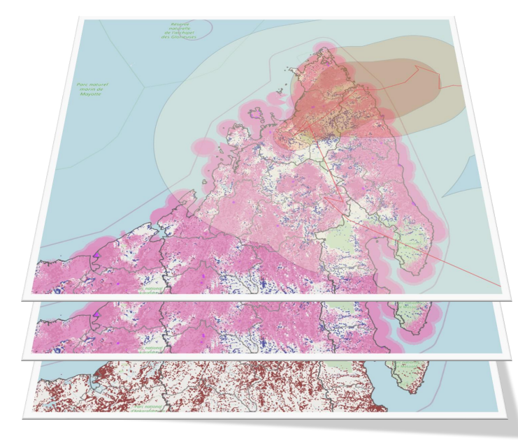
Project Summary
Problem:
The Early Warning Connectivity Map (EWCM) intersects population, connectivity and natural hazard datasets to identify populations who live in connectivity coldspots, and cannot therefore receive early warning messages because they live beyond the reach of fixed and mobile networks.
Background: In March 2022, the United Nations set a new target to ensure that everyone on earth should be protected by early warning systems by 2027. To reach this goal and to effectively protect people, we need to make sure that all areas of the 4 pillars of the early warning system work. These pillars are risk knowledge, led by UNDRR (UN Office for Disaster Risk Reduction), Monitoring, analysis, and forecasting led by WMO (World Meteorological Organisation), Warning dissemination and communication, led by ITU, and preparedness & response capabilities led by the International Federation of Red Cross and Red Crescent Societies (IFRC). The ITU is working to ensure early warnings reach people at risk by identifying connectivity gaps, hazards and vulnerable populations.
The EWCM has been developed by the International Telecommunications Union (ITU) and partners since 2024, and builds on the Disaster Connectivity Map (DCM) which was set up in 2020. The datasets used in the EWCM include:
Population density dataset: High resolution (100m), time-enabled population density datasets produced using artificial intelligence from satellite imagery by Planet Labs, Microsoft AI for Good Lab, and the Institute for Health Metrics and Evaluation (IHME) at the University of Washington.
Connectivity datasets: We overlay up to 10 connectivity and coverage datasets used in the ITU Disaster Connectivity Map (DCM) database to calculate what is the extent of fixed and mobile telecom coverages, and therefore which channels can be used to send early warning notifications.
The connectivity datasets include crowd-sourced Quality of Service fixed and mobile connectivity measurements provided by Ericsson Response, netBravo, Speedchecker, Ookla, Meta, and M-Lab which can reveal previously undocumented fixed broadband and 3G+ cellular coverage and also give near real-time view of connectivity.
The coverage datasets include official GSMA/ Collins Bartholomew coverage maps, OpenCellID, mobile operator coverage maps, and mobile operator cell site locations. For a number of countries we have generated high resolution predicted cellular coverage maps from mobile operator cell site locations using Radio Frequency modelling software developed for the GSMA by Masae Analytics and CloudRF.
Hazard datasets: The third part is when we overlay natural hazard datasets provided by the World Bank and UNDRR. The World Banks ThinkHazard! is used as a baseline dataset, which categorises 11 natural hazards (river flood, urban flood, coastal flood, earthquake, landslide, tsunami, volcano, cyclone, water scarcity, extreme heat, and wildfire) into four risk levels (high, medium, low and very low), to district level.
Results: The EWCM and datasets have been produced for more than 50 countries and territories by the end of 2025, and we plan to scale this to further countries during 2026. These results have been disseminated for validation to national regulatory authorities (NRAS), network operators, and national disaster management offices (NDMOs) through Early Warning for All National Consultative workshops held in more than 30 countries during 2024, 2025 and 2026.
Solution:
The EWCM uses AI-generated population density datasets to identify populations who cannot receive early warning messages because they live beyond the reach of fixed and mobile networks.
Technical Requirements:
Online access to the Early Warning Connectivity Map (EWCM) requires a web browser and broadband Internet connection.
Operational Environment:
Urban / Metropolitan
Rural
Coastal
Inland
High-Bandwidth / Stable Connectivity
Low-Bandwidth / Intermittent Connectivity
Countries / Region of Application:
Anguilla, Antigua and Barbuda, Aruba, Bahamas, Bangladesh, Barbados, Bermuda, British Virgin Islands, Cambodia, Cayman Islands, Chad, Comoros, Cuba, Curaçao, Djibouti, Dominican Rep., Ecuador, Ethiopia, Fiji, Guadeloupe, Guatemala, Guyana, Haiti, Jamaica, Kiribati, Lao P.D.R., Liberia, Madagascar, Maldives, Martinique, Mauritius, Montserrat, Mozambique, Nepal, Niger, Puerto Rico, Samoa, Sint Maarten, Solomon Islands, Somalia, South Sudan, Sudan, Tajikistan, Tanzania, Tonga, Trindad and Tobago, Turks and Caicos Islands, United States Virgin Islands, Uganda, Vanuatu.
Licensing or Cost Structure:
Free to use
Ethical and Governance Considerations:
Fairness and Equity: The AI component of the Early Warnings Connectivity Map (EWCM) involves estimating building density and height from satellite imagery. We sample training data from the whole world (not only relying on places with high density of labels) to train the model, and validate over space and time with held out data to ensure that there are no spatial/temporal biases.
Accountability and Governance: The EWCM uses multiple sources outlined above for coverage and connectivity measurements. The connectivity levels, availability and gaps displayed in the EWCM reflect the availability of these data sources and may in certain cases not provide the full connectivity picture. We invite ITU Member States, Mobile Network Operators, and other partners to review and validate the results, identify any gaps that might exist in the input data, and help us to improve the accuracy of the results. The results have been validated by ITU Member States in more than 30 Early Warning for All National Consultative workshops. In addition, a number of ground truth tests have also been carried out to compare results to actual connectivity levels observed on the ground.
Transparency and Explainability: The EWCM contains citations and a link to each of the coverage, connectivity, and hazard input sources used, and a disclaimer. In addition, the AI models that are used in the creation of the EWCM are documented publicly at https://github.com/microsoft/buildings and the gridded population map will be documented in an upcoming publication.
Security, Safety, and Reliability: There is no way for users to directly interact with the AI models in the EWCM. The AI models are used, in part, to create the gridded population dataset that is used in the map.
Privacy: How is privacy protected? The building density and height used to estimate gridded population is at a 40m/px spatial resolution and quarterly temporal resolution and are aggregated to a 100m/px spatial resolution in the EWCM. Given the range of cellular networks from cell sites, this 100m granularity is accurate enough to provide high resolution population coverage mapping, but is too coarse to derive any personally identifiable information (PII) or breach privacy.