
Google Groundsource
Project Summary
Problem:
While catastrophic events like earthquakes benefit from unified global sensor networks, hydro-meteorological hazards such as floods have no standardized observation infrastructure. Existing global archives tend to capture only large-scale or prolonged disasters, and the most comprehensive inventory maintained by the UN and European Commission holds roughly 10,000 entries.
Groundsource addresses this gap by systematically analyzing news articles in which flooding is the primary subject, processing reports across 80 languages and standardizing them into English via Google’s Cloud Translation API. research
The core of the pipeline relies on Gemini, which performs three key tasks on each article: First, it classifies whether an article describes an actual flood event versus something like a future warning or policy meeting. Second, it performs temporal reasoning anchoring relative phrases like “last Tuesday” to the article’s publication date to determine exactly when the event occurred. Third, it identifies precise locations down to neighborhoods and streets, then maps these to standardized geographic polygons using Google Maps Platform.
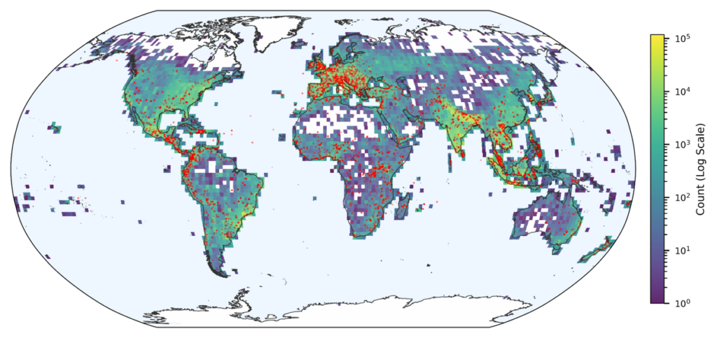
The resulting flash flood dataset covers more than 150 countries and spans from the year 2000 to the present, containing 2.6 million historical flood records. Manual validation found that 60% of extracted events were accurate in both location and timing, while 82% were accurate enough to be useful for real-world analysis for instance, correctly identifying the affected district or pinpointing the event within a day of its reported peak. Crucially, spatiotemporal matching showed that Groundsource captured between 85% and 100% of severe flood events recorded by established monitoring systems between 2020 and 2026.
Solution:
An AI-powered methodology developed by Google as part of its Crisis Resilience efforts, transforms decades of public reports into high-quality historical disaster datasets. Using Gemini to analyse millions of reports, the system identified over 2.6 million historical flood events and combined them with geospatial mapping to create a global urban flash flood dataset.
Technical Requirements:
(1) Use the Google Read Aloud user-agent to isolate primary text from 80 languages, which is standardized into English via the Cloud Translation API.
(2) Use the Gemini Large Language Model (LLM)
Classification: The model distinguishes between reports of actual, ongoing, or past floods and articles that merely discuss future warnings, policy meetings, or general risk modeling.
Temporal reasoning: Gemini anchors relative references (e.g., “”last Tuesday””) against an article’s publication date to determine precise event timing.
Spatial precision: The system identifies granular locations (neighborhoods and streets) and maps them to standardized spatial polygons using using Google Maps Platform.
Operational Environment:
High-Bandwidth/Stable Connectivity
Coastal
Urban/ Metropolitan
Rural
Inland
Low-Bandwidth / Intermittent Connectivity
Licensing or Cost Structure:
Open-source