
Page 94 - Kaleidoscope Academic Conference Proceedings 2022
P. 94
2022 ITU Kaleidoscope Academic Conference
4
of these mappings are done through LD views , each of One such application, the most recent of which to be
which transform the data from the key register source dataset developed using the KKG as the data source, is the
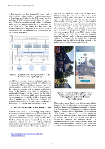
to linked data conforming to the SOR model based on Augmented Reality (AR) application. As illustrated in
predefined SPARQL construct queries. These LD views, in Figure 4, the application allows the user to scan their
using SPARQL construct functionality, take a part of a data environment for buildings within a given location and then
model from a key register and map this to an associated part choose a specific building to retrieve information about that
of the SOR model. This process is a key part of the building on their screen. As such, the application can be
architecture outlined by the authors as this serves to preserve categorized as a visualization application for geospatial data
the provenance and traceability between the source data and and is an example of an application which supports users
that available in the KKG. with using geospatial data from the KKG without needing
any knowledge of linked data or querying languages,
supporting Kadaster’s ambition for making geoinformation
available for everyone. The application itself is querying
information from the KKG which is then rendered by the
application and displayed as shown in Figure 4.
Figure 3 – Architecture for the implementation of the
Kadaster Knowledge Graph [6]
The KKG is now available for use in the Kadaster triple store
environment and contains approximately 680 million triples.
The data in the KKG is updated on a quarterly basis in line
with the quarterly updates of the linked data publication of
the various key registers and an updated notification is
posted in the Kadaster triple store on completion. As
highlighted in Figure 2, it is the intention that the KKG is Figure 4 – Screenshots displaying house icon and
used directly by applications which access the data various building information from the augmented
service options (e.g. SPARQL, REST or GraphQL) and, reality application built on the Kadaster
indeed, it is in this manner that the Augmented Reality (AR) Knowledge Graph
application described in the following sections makes use of
Kadaster data in providing functionality to end users. What is not obvious to the user when the information is being
displayed is that the information has provenance in several
4. THE AUGMENTED REALITY APPLICATION distributed data sources, both those maintained by Kadaster
as well as those provided by other organizations such as the
Within Kadaster, the KKG is increasingly being used as a Bureau of Statistics in the Netherlands (Dutch acronym:
data source for various applications, particularly where the CBS). Indeed, the address of the building (adres), the
applications require the availability of data from various key building year (bouwjaar) and the floor size of the building
registers and/or other data sources. Making use of the KKG, (oppervlakte) are all originally sourced from the Key
therefore, allows this data to be queried and used in the Register for Addresses and Buildings (BAG). The
application without the need to perform additional neighborhood (buurt) and the number of schools within 3 km
transformation or integration steps in order for the data to be (aantaal basisscholen binnen 3 km) are originally published
used in an integrated manner within the given application. in the CBS districts and neighborhood dataset. These, based
4 https://labs.kadaster.nl/demonstrators/architectuur-
selfservice/LDViews/ .
– 48 –