
Page 150 - Kaleidoscope Academic Conference Proceedings 2020
P. 150
2020 ITU Kaleidoscope Academic Conference
1.3 Marker-less Based Augmented Reality
Unlike marker-based AR, marker-less AR does not depend
on AR markers to function, instead they use natural features
that already exist in the environment [7]. Determination of
the camera position by natural features is more intricate than
the marker-based AR and involves using adding algorithms to
discover and match the natural features amongst the camera
frames.
The marker-less AR can also utilize other sensors such as Figure 2 – Marker based AR layout
GPS (location-based AR), digital compass, accelerometer,
or velocity meter which are often built into the device to
deliver data based on your position. The use cases are
vast and include the following: position detection, finding
nearby places or businesses, mapping directions, and other
position-centric mobile applications [7].
1.4 Projection Based Augmented Reality
Projection-based AR can be defined as a video prognosis
technique, which can extend and support visual data by
hurling images on the surface of 3D items or space. It is
often referred to as Spatial AR [8]. Projection-based AR is
able to project high-definition pictures or videos and alter the
shapes of objects visually using the flow of time.
The audience in this case is allowed to identify a visually Figure 3 – System Architecture
extended space with the combination of images and real
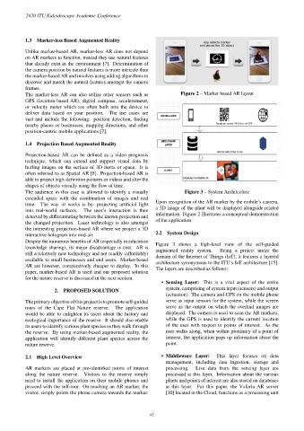
Upon recognition of the AR marker by the mobile’s camera,
time. The way -it works is by- projecting artificial light
a 3D image of the plant will be displayed alongside related
into real-world surfaces. The user’s interaction is then
information. Figure 2 illustrates a conceptual demonstration
detected by differentiating between the known projection and
of the application.
the changed projection. Laser technology is also amongst
the interesting projection-based AR where we project a 3D
2.2 System Design
interactive hologram into mid-air.
Despite the numerous benefits of AR (especially in education
Figure 3 shows a high-level view of the self-guided
knowledge sharing), its major disadvantage is cost. AR is
augmented reality system. Being a project under the
still a relatively new technology and not readily (affordably)
domain of the Internet of Things (IoT), it features a layered
available to small businesses and end users. Marker-based
architecture synonymous to the ITU’s IoT architecture [15].
AR are however, comparatively cheaper to deploy. In this
The layers are described as follows:
paper, marker-based AR is used and our proposed solution
for the nature reserve is discussed in the next section.
• Sensing Layer: This is a vital aspect of the entire
system, comprising of system input (sensors) and output
2. PROPOSED SOLUTION
(actuation). The camera and GPS on the mobile phone
The primary objective of this project is to promote self-guided serve as input sensors for the system, while the screen
tours of the Cape Flat Nature reserve. The application serve as the output on which the overlaid images are
would be able to enlighten its users about the history and displayed. The camera is used to scan the AR markers,
ecological importance of the reserve. It should also enable while the GPS is used to identify the current location
its users to identify various plant species as they walk through of the user with respect to points of interest. As the
the reserve. By using marker-based augmented reality, the user walks along, when within proximity of a point of
application will identify different plant species across the interest, the application pops up information about the
nature reserve. point.
2.1 High Level Overview • Middleware Layer: This layer focuses on data
management, including data ingestion, storage and
AR markers are placed at pre-identified points of interest processing. Live data from the sensing layer are
along the nature reserve. Visitors to the reserve simply processed at this layer. Information about the various
need to install the application on their mobile phones and plants and points of interest are also stored on databases
proceed with the self-tour. On reaching an AR marker, the at this layer. For this paper, the Vuforia AR server
visitor, simply points the phone camera towards the marker. [10] located in the Cloud, functions as a processing unit
– 92 –