
Page 160 - Proceedings of the 2018 ITU Kaleidoscope
P. 160
2018 ITU Kaleidoscope Academic Conference
For each iteration of the above steps, the count of true
positives (TP) will be increased by one for each matching
polygon found, the count of false positives (FP) will be
increased by one for each non-matching polygon and
finally, when every detected polygon was processed, for
each unmatched polygon (undetected truth polygons) the
count of false negatives (FN) will be increased by one.
The precision and recall of the algorithm are defined as
follows:
= /( + )
= /( + )
Finally, the F-score of the algorithm is defined as 0 if either
Precision or Recall is 0. Otherwise:
2 ∗ ∗
= +
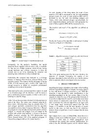
Table 1 – Algorithm accuracy in each city with the F-Score
metric [15]
Figure 7 – Kohei Ozaki‘s ConvNet Architecture City Accuracy
Fortunately, for the project‘s feasibility, the model Las Vegas 0.885
described above, together with its source code, is available Paris 0.745
for free use in a Docker container, which allows, having Shanghai 0.597
enough hardware and software resources, to train the Khartoum 0.544
network and to use it by deploying the container and
executing basic instructions in the command line. This is the great starting point for the main objective: the
detection of changes. Comparing the outputs of the
Particularly, the container was deployed in a p2.xlarge inference algorithm is what will allow us to finally achieve
instance of Amazon Web Services, with an Ubuntu 16.04 what is expected, which is developed in the next section.
operative system. This instance has the advantage of having
61GB of RAM memory and a nVidia K80 Tesla GPU, 5. IMAGE COMPARISON
enough resources to obtain an acceptable performance
according to the needs of the project. Regarding the image comparison, the output of the building
detection algorithm is helpful to compare two inputs spaced
After running the code, a trained algorithm ready to be used in time and know if changes occurred or not. With this
in its inference stage will be obtained. It will be ready to objective, it was decided to make modifications to the
give a sufficiently accurate response of what is and is not a algorithm mentioned in the last section. Since it has the
building in a satellite image. capacity to obtain the area of the polygons that it detects, it
is possible to determine for specific coordinates, how many
Table 1 shows the accuracies obtained from the test data for square meters of construction were found. Then, if for the
each of the cities. The values were obtained using the F- same coordinates the inference algorithm is run again with
Score metric, following these steps to calculate them. For a new image input -temporarily spaced from the first
each polygon (probable construction) that the algorithm image-, it is possible to get the new quantity of square
was capable to detect, these 4 steps are followed: 1- Discard meters in this zone, in such way that if the difference
the polygon if it was already matched with another solution between them is significant, it can be assured that the area
polygon. 2- Discard the polygon if is not related to the has changed.
polygon with which it has matched. 3- If none of the above
options occurred, calculate the IOU (Intersection over Input images have a size of 200mx200m, when there is a
Union, Jaccard index) [14] of the matched polygons. 4- change in some sector within this square, it is necessary to
Discard the polygons with an IOU lower than 0.5. identify in some way to which geographical area
corresponds that portion that suffered modifications. To
achieve this, the 200x200 squares will be labeled with a
– 144 –