
Page 157 - Proceedings of the 2018 ITU Kaleidoscope
P. 157
Machine learning for a 5G future
control of changes in the territory applying Deep Learning
techniques to orthophotos is just the first example of the
capabilities that the combination of Artificial Intelligence
and spatial information can offer for the generation of
territorial knowledge.‖ [9]. Such a statement serves as a
proof of evidence that there are professionals and
specialized technicians working with these techniques
which are to be applied, extended and consolidated in the
next years. The proposed solution is our contribution to get
an innovative, feasible and time scalable solution.
In conclusion, the main goal of the project is to propose the
development of a software solution to support the detection
of changes in building structures, comparing satellite
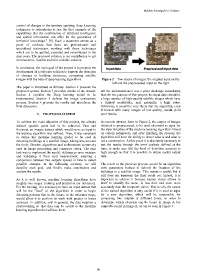
images with the help of deep learning algorithms. Figure 2 – Two stacks of images: the original input on the
left and the preprocessed input on the right
The paper is structured as follows: Section 2 presents the
proposed system. Section 3 provides details of the dataset. All the aforementioned was a great challenge considering
Section 4 explains the Deep learning model to be that, for the purpose of this project, the input data should be
implemented. Section 5 defines the image comparison a large number of high-quality satellite images which have
process. Section 6 presents the results and introduces the a limited availability, and, generally, a high price.
final discussion. Otherwise, it would be very likely that the algorithm, even
if trained with many images of low quality, would yield
2. PROPOSED SYSTEM poor results.
To achieve the main objective of this project, the already As seen in abstract form in Figure 2, the corpus of images
defined specific goals had to be achieved. First and obtained is preprocessed, to be used afterward as input for
foremost, an images dataset which would serve as input to the layer structure of the machine learning algorithm. Based
the training algorithm was defined. Then, it was necessary on certain parameters, and after finishing the process, the
to define the machine learning model to be used in algorithm will have the ability to detect what is and what is
detecting buildings in a satellite image, taking into account not a construction. At this point it is absolutely necessary to
the tools, libraries, algorithms and architectures commonly test the results through the error analysis defined at the
used in image processing and computer vision. The next time, to make sure that the level of detection accuracy is
task was to implement the model, defining an error measure high enough so that it is possible to obtain useful output
and validating it from said measurement, enabling a data.
comparison between two outputs spaced in time to detect
possible changes. In the following sections, we will The result of the previous process would be an algorithm
describe each goal, and finally make conclusions and with parameters trained to delimit the location of the
analyze the results. buildings in a satellite image. This output is useful, but it
still does not represent the final result yet. Indeed, it is
As it is well known, machine learning algorithms have important to achieve it because human vision allows in
roughly two stages: training and prediction (or inference). itself to identify the same, in less time and even more
For the training, it is necessary to have an input dataset that accurately than the computer vision. That is why the output
will be the "food" of the algorithm in order to begin of the trained algorithm is only useful if it is used as input
detecting patterns that in the future, in the inference stage, for a new algorithm, which will be responsible for
would allow it to perform its work with greater or lesser comparing two outputs at different times, in order to
accuracy. In addition, and in general, the data requires a determine which elements can be found in image A but
preprocessing so that they can be useful to the machine cannot be found in image B, as can be seen in Figure 3.
learning algorithm that will use them.
– 141 –