
Page 70 - 5G Basics - Core Network Aspects
P. 70
1 Core network aspects
sessions. This service scenario shows how DAN elements close to end users can provide edge computing
services.
7.4 Automated driving
This service scenario describes DAN as a collaborative architecture to support seamless communication for
automated driving. The automated driving scenario is associated with network-assisted driving for human
drivers. Automated vehicles pull the NDOs they demand, e.g., position data, accident or traffic jam
information, when they go on a road. The service provider pushes positional data or other NDOs to vehicles
at specific positions (corresponding to different areas) of road via access points (APs) that act as DAN
elements. As NDOs are used as interactive content, the service provider needs to guarantee low latency (less
than a valid threshold value) for high QoS, in the case of automated driving.
To provide real-time mobility access, mobile nodes may have different identifiers assigned from a separate
namespace, e.g., node name as shown in [b-López, 2016].
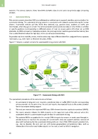
Figure 7-7 depicts a sample scenario for automated driving service with DAN.
Figure 7-7 – Automated driving with DAN
The operational procedures of the scenario are as follows:
1) An automated driving end user requests a positional data or traffic NDO from the corresponding
service provider. At the same time, the end user reports the expected route to the service provider
for the automated driving support.
2) The end user receives the requested NDO via a DAN element (wireless application protocol (WAP)).
3) The service provider informs the DAN elements on the expected route of the end user where the
automated vehicle is authenticated to get the data for automated driving.
4) The updated NDOs are pushed to the nearby DAN elements by sensors or newly pass-through in-
vehicle devices to maintain the accuracy of current traffic data and support seamless retrieval of
data with low latency for the automated driving end user. Even if the DAN network provider fails,
e.g., due to disaster, the end user can still receive geographical and positional data, such as
intersection information and hidden objects on the road, as well as GPS for navigation.
60