
Page 528 - Shaping smarter and more sustainable cities - Striving for sustainable development goals
P. 528
and tamper alerts, and can also enhance the identification of peak demand mainly for energy.
Customer and provider relationships are improved through increased communication, utilities can
improve their tariffs policies and consumers can be equipped with options like on‐line alarms in case
of leak or suspicious consumption, or the possibility to change payment methods (e.g. prepaid or
postpaid).
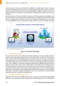
Smart metering also allows water utilities to provide clear water consumption information which
can help customers to track and control their water usage, and identify immediate savings on their
bills, thus enabling better distribution network and consumption planning due to its real‐time
monitoring capabilities. Figure 9 illustrates an example of AMI infrastructure and SWM capabilities.
27
Source: Alliance for Water Efficiency (2014).
Figure 9 – Smart meter technologies
c. Communication modems
Communication solutions include Bluetooth, Wireless M‐Bus communication, global system for
mobile communications/general packet radio service (GSM/GPRS), and Ethernet, among others.
These solutions allow remote reading of sensors and meters by the direct transfer of real‐time or
time‐stamped data to the central management system of the utility or water authority. The data is
then made available online for customer information system (CIS), geographic information systems
(GIS), cloud computing or supervision and data management tools, supporting improved decision‐
making within the system. Such communication devices incorporated with smart meters/sensors
can also provide alerts to authorities (e.g. reverse flow, leak alert, fraud alarm, and battery levels,
water quality alarms). Most of these types of communication solutions ensure spatial redundancy
and enable a wide range of coverage between distant buildings, housing estates, and other districts.
In the traditional collection systems, considerable amounts of time would have been wasted finding
and measuring points, especially in remote locations.
d. Geographic information systems (GIS)
Geographic information systems (GISs) allow to capture, manage, analyse and display geographical
information for underground assets description and decision‐making. GIS has a wide range of
518 ITU‐T's Technical Reports and Specifications