
Page 305 - Shaping smarter and more sustainable cities - Striving for sustainable development goals
P. 305
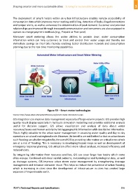
The deployment of smart meters within an urban infrastructure enables remote accessibility of
            consumption data which improves meter reading and billing, detection of leaks, illegal connections
            and tamper alerts, as well as enhances the determination of peak demand. Customer and provider
            relationships are improved through increased communication and consumers are also equipped to
            options to change payment methods (e.g., Prepaid or Post‐paid).

            Moreover  smart  metering  allows  the  water  utilities  to  provide  clear,  water  consumption
            information  which  can  help  customers  to  track  and  control  their  water  usage  and  thereby see
            immediate savings on their bills thereby enabling better distribution network and consumption
            planning due to the real‐time monitoring capabilities.


                                          Figure 53 – Smart meter technologies
            Source: http://www.allianceforwaterefficiency.org/smart‐meter‐introduction.aspx
            GIS integration can improve data management especially of large volume projects. GIS provides high
            quality result display especially in hydraulic simulation modelling and provides additional analysis
            useful  for  decision  support.  GIS  allows  visualization  and  analysis  of  data  about  water
            resources/issues and human activity by linking geographic information with descriptive information.
            This is highly valuable to the urban water management in assessing water quality and day to day
            operations on a local and regional scale. However, its benefits are not limited to that as urban issues
            such flooding can also be mitigated by the use of GIS by providing information on critical areas which
            are at a risk of flooding. This is necessary in developing hazard maps as well as development of
            emergency response planning. GIS utilization offers more robust analysis, increased efficiency and
            reduced costs.
            By integrating information from resource satellites, GIS can cover large river basins which some
            cities occupy. Combined with local rainfall patterns, meteorological and hydrological data, as well
            as  drainage  systems,  GIS  improve  urban  storm  water  management  by  strengthening  drainage
            management and enhance rainwater reuse. This helps to reduce the prevalence of urban flooding
            which  is  increasing  in  cities  since  the  development  of  infrastructure  in  cities  has  created  large
            expanses of impermeable earth.


            ITU‐T's Technical Reports and Specifications                                                 295