
Page 196 - AI for Good Innovate for Impact
P. 196
AI for Good Innovate for Impact
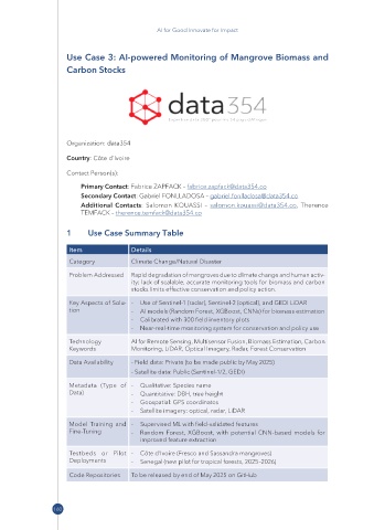
Use Case 3: AI-powered Monitoring of Mangrove Biomass and
Carbon Stocks
Organization: data354
Country: Côte d’Ivoire
Contact Person(s):
Primary Contact: Fabrice ZAPFACK – fabrice.zapfack@ data354 .co
Secondary Contact: Gabriel FONLLADOSA – gabriel.fonlladosa@ data354 .co
Additional Contacts: Salomon KOUASSI – salomon.kouassi@ data354 .co, Therence
TEMFACK – therence.temfack@ data354 .co
1 Use Case Summary Table
Item Details
Category Climate Change/Natural Disaster
Problem Addressed Rapid degradation of mangroves due to climate change and human activ-
ity; lack of scalable, accurate monitoring tools for biomass and carbon
stocks limits effective conservation and policy action.
Key Aspects of Solu- - Use of Sentinel-1 (radar), Sentinel-2 (optical), and GEDI LiDAR
tion - AI models (Random Forest, XGBoost, CNNs) for biomass estimation
- Calibrated with 300 field inventory plots
- Near-real-time monitoring system for conservation and policy use
Technology AI for Remote Sensing, Multisensor Fusion, Biomass Estimation, Carbon
Keywords Monitoring, LiDAR, Optical Imagery, Radar, Forest Conservation
Data Availability - Field data: Private (to be made public by May 2025)
- Satellite data: Public (Sentinel-1/2, GEDI)
Metadata (Type of - Qualitative: Species name
Data) - Quantitative: DBH, tree height
- Geospatial: GPS coordinates
- Satellite imagery: optical, radar, LiDAR
Model Training and - Supervised ML with field-validated features
Fine-Tuning - Random Forest, XGBoost, with potential CNN-based models for
improved feature extraction
Testbeds or Pilot - Côte d’Ivoire (Fresco and Sassandra mangroves)
Deployments - Senegal (new pilot for tropical forests, 2025–2026)
Code Repositories To be released by end of May 2025 on GitHub
160