
Page 33 - Turning digital technology innovation into climate action
P. 33
Turning digital technology innovation into climate action
transmitters operating on or near the surface of the Earth. These sensitive receivers can
operate successfully only because of the allocation of certain frequency bands to their Chapter 3
respective radio services and the regulatory protections afforded to them by many special
provisions of the Radio Regulations.
It is important to note that while meteorological and Earth observation satellites are
operated by a limited number of countries, the data and data products that result from
their operation are distributed and used on a global basis, in particular by national weather
services in developed and in developing countries, and by organizations monitoring and
studying climate change. Furthermore, data from Earth observation and remote sensing
systems are used widely in applications for disaster prediction, monitoring and mitigation.
This is crucial, as a United Nations (UN) report has found that approximately 90 per cent
of all disasters are weather-related.
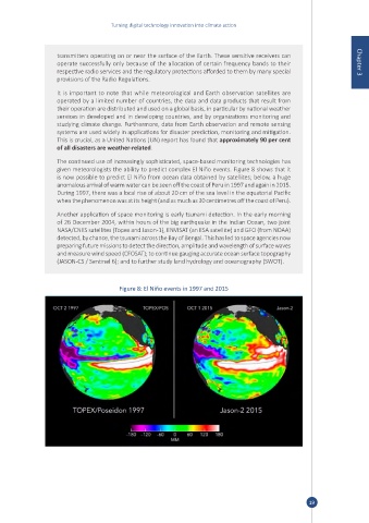
The continued use of increasingly sophisticated, space-based monitoring technologies has
given meteorologists the ability to predict complex El Niño events. Figure 8 shows that it
is now possible to predict El Niño from ocean data obtained by satellites; below, a huge
anomalous arrival of warm water can be seen off the coast of Peru in 1997 and again in 2015.
During 1997, there was a local rise of about 20 cm of the sea level in the equatorial Pacific
when the phenomenon was at its height (and as much as 30 centimetres off the coast of Peru).
Another application of space monitoring is early tsunami detection. In the early morning
of 26 December 2004, within hours of the big earthquake in the Indian Ocean, two joint
NASA/CNES satellites (Topex and Jason-1), ENVISAT (an ESA satellite) and GFO (from NOAA)
detected, by chance, the tsunami across the Bay of Bengal. This has led to space agencies now
preparing future missions to detect the direction, amplitude and wavelength of surface waves
and measure wind speed (CFOSAT); to continue gauging accurate ocean surface topography
(JASON-CS / Sentinel 6); and to further study land hydrology and oceanography (SWOT).
Figure 8: El Niño events in 1997 and 2015
19