
Page 39 - Enhancing innovation and participation in smart sustainable cities
P. 39
United for Smart Sustainable Cities
Enhancing Innovation and Participation
2.2 Implementation of concept of “Fit-For-Purpose”
There is no specific design for a land registry system. Local traditions, existing infrastructure, etc. will require
different solutions, especially in countries where cadastres have been in operation for many decades.
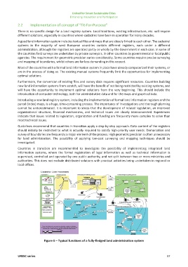
A good land information system includes textual files and maps that are closely linked to each other. The cadastral
systems in the majority of west European countries contain different registers, each under a different
administration, although the registers are operated partly or wholly by the Government in each case. In some of
the countries field surveys are undertaken by private surveyors, in other countries by governmental or local public
agencies. The requirement for geometric precision varies considerably. Some countries require precise surveying
and mapping of boundaries, whilst others are far less demanding in this respect.
Most of the countries with a formal land information system in place have already computerized their systems, or
are in the process of doing so. The existing manual systems frequently limit the opportunities for implementing
optimal solutions.
Furthermore, the conversion of existing files and survey data requires significant resources. Countries building
new land information systems from scratch, will have the benefit of not being restricted by existing systems, and
will have the opportunity to implement optimal solutions from the very beginning. This should include the
introduction of computer technology, both for administrative data and for the maps and graphical data.
Introducing a new land registry system, including the implementation of formal land information registers and the
parcel (index) maps, is a huge, time-consuming process. The importance of investigations and thorough planning
cannot be underestimated. It is important to stress that the development of related legislation, an improved
organizational structure, financial mechanisms, and technical issues are closely interconnected. Experiences
indicate that issues related to legislation, organization and funding are frequently more complex to solve than
most technical issues.
Guidelines recommend that countries in transition apply a step-by-step approach. Data content of the registers
should initially be restricted to what is actually required to satisfy high-priority user needs. Demarcation and
survey of boundaries are frequently a major element of the process. High geometric precision is often unnecessary
for land administration. The possibility of applying low-cost surveying and mapping techniques should be
investigated.
Countries in transition are recommended to investigate the possibility of implementing integrated land
information systems, where the formal registration of legal information as well as technical information is
supervised, controlled and operated by one public authority, and not split between two or more ministries and
authorities. This does not exclude distributed solutions with practical activities being undertaken in regional or
local offices.
Figure 6 – Typical functions of a fully-fledged land administration system
U4SSC series 37