Designing spectrum monitoring networks in the Kyrgyz Republic
 |
| B.N. Nurmatov, Deputy Director of the State Communications Agency of the Kyrgyz
Republic
|
Although spectrum management in the Kyrgyz Republic is assured by means of a
well-developed system, spectrum monitoring lags behind other domains such as frequency
assignment, licensing, and administration. To improve the situation, the State Communications
Agency (SCA), the national body responsible for regulatory matters and spectrum
management, decided to design and implement a network of fixed monitoring stations,
particularly for VHF and UHF. The challenge it faced was how to tackle the design
process.
Ideally, a network should be optimized at the design stage, taking into account
future developments to provide the best mix of functional and operational capabilities
while keeping costs to a minimum. However, two factors have made it difficult to
apply this principle in Kyrgyzstan: lack of design tools (until recently), and the
country’s complex terrain — much of it consists of high mountains. The answer was
found in the first-ever use of new planning tools designed by ITU.
ITU model helps in planning
To assist in their task, SCA looked at the methodology that was developed in
Study Group 1 of the ITU Radio-communication Sector (ITU–R), and implemented in
a software application, for use in optimizing the design of spectrum monitoring
networks.1 The methodology involves the calculation of actual coverage
areas (based on exact terrain data) for various spectrum monitoring functions such
as listening, emission parameter measurement, direction finding (DF), and location
determination (LD) by triangulation — a function that is as important as it is difficult.
Location determination by triangulation depends on the availability of bearing
data from at least two monitoring/direction-finding stations, and is thus subject
to significant constraints that do not affect other functions which can be performed
by a single station working alone. Furthermore, location uncertainty is a phenomenon
that can vary considerably, as it depends not only on the distance from the direction
finding/monitoring stations, but also on the angles formed by the crossing of bearings.
Thus, any given combination of DF stations is associated with a specific pattern
of LD uncertainties (known as the Kogan-Pavlyuk location template), which is also
dependent on the actual terrain. This makes it impossible to predict location coverage
features without a detailed simulation. For this reason, LD is the most critical
function in spectrum monitoring, and should be taken as a basis for planning a spectrum
monitoring network.
 |
|
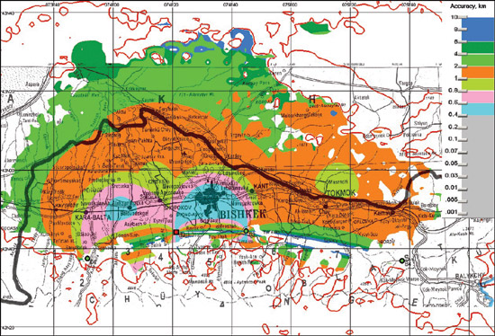
| In the Chuisk region of Kyrgyzstan, four spectrum monitoring stations are
distributed in the optimum arrangement determined by the computer simulation. The
Kogan-Pavlyuk location template shows how the level of accuracy has been maximized
around the capital, Bishkek, and in other highly populated areas. (The heavy line
is the border with Kazakhstan.)
|
|
The Istanbul Action Plan in operation
Convinced by the study results achieved at ITU–R, the State Communications Agency
requested that ITU’s Telecommunication Development Bureau conduct a technical assistance
project in the Kyrgyz Republic to propose the design of the planned spectrum monitoring
network. This falls under Programme 2 of the Istanbul Action Plan, and the response
from ITU was prompt.
The project was conducted by an ITU expert in close cooperation with senior SCA
personnel. It was decided to determine the minimum number of V/UHF monitoring/direction-finding
stations and their optimum geographical placement with respect to three local monitoring
networks, for the Chuisk and Issyk-Kul administrative regions and for portions of
the Osh and Jalal-Abad regions. The various monitoring functions (listening, emission
parameter measurement, DF and LD by triangulation) were to be available throughout
the densely populated portions of those regions. The location uncertainties were
to be minimized in the country’s major urban centres: the capital Bishkek and the
cities of Jalal-Abad, Osh and Karakol.
Simulations lead to higher accuracy
The dedicated software application produced a series of simulations that were
compared to find the optimum solution with regard to the number of stations and
their sites. The best arrangement of stations was determined using the digital terrain
map (DTM) data at a resolution down to 100 metres horizontally and less than 2 metres
in the vertical axis. Digital maps for display purposes were produced using standard
geographical maps at a scale of 1:1 000 000.
Three local networks were designed for spectrum monitoring within three main
lowland areas of the country. Initially, each local network will consist of four
fixed spectrum monitoring/DF stations, later to be expanded to five. This arrangement
of stations in the Chuisk region, for example, with known DF instrumentation uncertainties
of one degree, allows LD by triangulation to reach an accuracy of 0.6-0.8 kilometres
within the Bishkek city area. Virtually the entire lowland portion of the region
is covered at an acceptable accuracy of 2 kilometres or less.
Similar results were obtained for the other regions. The exercise made it possible
not only to specify the number and best placement of the monitoring stations for
all three local networks, but also to derive the optimum ratio of measuring and
DF stations for those networks.
Computer-designed spectrum monitoring
This international project showed, for the first time, how it is possible to
use state-of-the-art methodology and a dedicated software application to design
a spectrum monitoring network from the ground up (or to optimize an existing one).
Detailed simulations that took account of the mountainous Kyrgyz terrain were able
to produce an effective plan.
1 “Handbook on computer-aided techniques for spectrum management”
chapter 5, example 9; and Annex 1 to ITU–R Document 1C/54 of the current study period.
|

