Watching the weather, climate and water
WMO promotes the use of ICT to warn against disaster
Weather events of unusual severity or abnormal duration pose a threat to life,
property, human activities and the environment. However, although severe weather
can affect anywhere in the world, of the three million people killed in the past
twenty years by disasters such as hurricanes, floods and droughts, 90 per cent were
living in developing countries. In addition to the direct damage extreme weather
events cause, they also have serious effects on food security and health, as well
as the continuing problems of desertification, famine and mass migration.
The negative impacts of weather and climatic conditions can be reduced if information
reaches people in time for them to take effective action. In line with the vision
of the World Summit on the Information Society (WSIS), the World Meteorological
Organization (WMO) is using information and communication technologies (ICT) to
produce increasingly accurate and reliable data that gets to those who need it in
a timely manner. ICT systems are required for:
- The collection and exchange of Earth observations, especially related to weather,
climate and the water cycle, needed for analysis, monitoring and forecasting
- The delivery of information and warnings to help protect lives and property,
and to assist the wide range of weather-sensitive economic sectors that contribute
to development.
|
 ICRC
ICRC
Disaster prevention |
An ongoing challenge is the fact that developing countries, which are among the
most exposed to natural disasters, often have limited ICT infrastructure and services
remain largely unavailable or unaffordable. These countries are thus least able
to benefit from advances in the application of weather, climate and water information,
which can have such a great impact on people’s lives and a nation’s development.
The Plan of Action of the 2003 Geneva Phase of WSIS includes the use of ICT to
establish systems to monitor and forecast the impact of natural and man-made disasters,
particularly in developing countries. It also cites as a goal the promotion of long-term
systematic and efficient collection, dissemination and preservation of essential
scientific data in all countries. Through many of its programmes, WMO is committed
to promoting and supporting the implementation of ICT for these purposes. The aim
is to improve the global, regional and national production, exchange and distribution
of information and warnings on weather, climate and water. Already, several activities
are being undertaken by WMO that are in line with the WSIS Plan of Action.
Within the framework of the WMO World Weather Watch programme, the National Meteorological
and Hydrometeorological Services of the 187 WMO members exchange real-time data
via the Global Telecommunication System (GTS), which consists of dedicated links,
data communication networks and satellite-based systems. Weather knows no borders,
and the delivery of effective services depends on these exchanges of information.
The GTS supports the international distribution of early warnings about weather,
climate and water-related natural disasters, including tsunami warnings in the Pacific
and Indian Oceans. The Internet too plays an increasing role in disseminating data
to all types of user, from individuals to scientific research bodies.
|
 DigitalGlobe
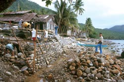
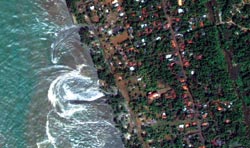
The tsunami
(Sri Lanka, December 2004) |
|
Building upon the most successful components of existing WMO information systems,
the organization has also begun developing a coordinated global information infrastructure,
the WMO Information System (WIS), for the collection and sharing of meteorological
data among all relevant international programmes. The key element of the system
will be a comprehensive, global online catalogue of data, including the necessary
metadata, which is intended to serve the entire community of users. WIS is to be
based on modern data communication services such as the Internet, and it is expected
to be a major component of the Global Earth Observation System of Systems (GOESS).
In addition, WIS will employ international ICT industry standards. With its long
experience in developing these, WMO actively promotes the use of international standards
to ensure the design of cost-effective information systems, making it much easier
for them to be implemented by developing countries. The WSIS Plan of Action includes
the promotion of metadata standards to promote the effective collection and use
of data needed for scientific research. WMO is currently developing meta-data standards
within an International Organization for Standardization (ISO) framework concerning
geographic information (the ISO 19100 series) with a view to enabling universal
access to, and use of, weather, climate and water information.
Since the first weather-monitoring networks were launched in the 19th century
with the advent of the telegraph, ICT has played a key role in disseminating meteorological
data. In its work, WMO will continue striving to make the best possible use of the
latest technological developments, and to promote the worldwide use of ICT to help
when natural disasters threaten to strike. "
| Contributed by Pierre Kerhervé, WMO. |
|

