 © Louise Murray/Alamy
|
The role of information and communication technologies
Information and communication
technologies (ICT) provide us with an unprecedented ability to
collect and analyse environmental information that may encompass
the entire terrestrial system, from the depths of the ocean to
the upper reaches of the atmosphere. They enable us not only to
assess the impact of humans on the environment, but also to
manage our use of energy and production of greenhouse gases (in
the home and in industry). Thus, ICT are an essential part of
efforts to combat climate change and to mitigate its effects.
Reducing CO2
emissions
Previous articles in
ITU News (most recently in the October 2008 issue,
Combating climate change,
The enabling effect of ICT) have
detailed how ICT can help substantial cuts to be made in
emissions of the greenhouse gases that are leading to global
warming. The methods by which this can be achieved include, for
instance, using computer controls to improve the performance of
engines in factories; distributing goods more efficiently
through computerized management of transport and warehouses;
allowing people to meet or work remotely via videoconferencing,
and using sensor networks to control the heating and lighting in
buildings so that energy is not wasted.
Although ICT themselves contribute to
greenhouse gas emissions, they help to save much greater amounts
emitted by all other sectors of industry. And efforts are being
made to reduce the carbon footprint of ICT equipment. In
computer monitors and television sets, for example, flat, liquid
crystal displays (LCD) use half the energy of cathode ray tubes—
and do not contain harmful pollutants. Next-generation networks
(NGN), especially those based on optical fibre, also need less
power. In turn, NGN lead to more efficient communication systems
that form the backbone of energy-saving applications (see
Next-generation networks will help mitigate climate change).
Keeping watch on the environment
Mitigating the effects of climate change
is the other major task in which ICT are involved. The tools
that are available are listed in the box ICT
tools for mitigating climate change. ICT can be
used in a number of ways to study and manage the environment,
locally and globally. These come under three broad headings:
observation, analysis, and sharing of data.
Observation
|
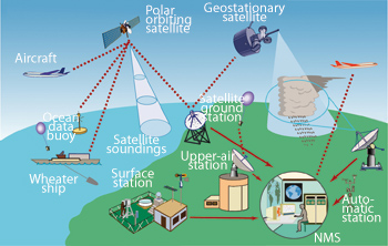
Figure 1 — The WMO Global Observing System
|
WMO |
|
Satellite-based sensors monitor and provide information on barometric pressure, water temperature and wave action. This is supplemented by data from land-based sensors, relayed by radio telemetry. Other platforms are also used, including commercial aircraft, specialized weather observation aircraft, weather balloons and ships. |
Our planet’s land and oceans can be
monitored through sensors placed directly on the surface, or
remotely by satellite. The condition of the atmosphere can be
checked for greenhouse gas emissions and wind currents that may
presage a hurricane. Satellite images came into the public
domain with the launch of LANDSAT 1 in 1972. However,
meteorological satellites were used in the 1960s by the World
Meteorological Organization (WMO) for its
World Weather Watch programme — one of the most valued
satellite applications, which is used every day throughout the
world. WMO also operates the Global Observing System to monitor
weather conditions and alert authorities (see Figure 1).
Analysis and modelling
Once environmental data have been
collected, various computational and processing tools are
required to perform an analysis. The more powerful the computer,
the faster and more complex will be the research. As well as
conventional supercomputers, the processing power of ordinary
computers can be employed for the task, through grid computing.
Via the Internet, this method of distributed computing loosely
links together machines that may be thousands of kilometres
apart and sited in a business, a university or someone’s home.
In addition to analysing data, the combined computer power can
be put to the task of creating models of climate change, for
example, that are invaluable for policy-makers. An example of
grid computing used for these purposes was the world’s
largest-ever climate modelling experiment, organized in 2006 by
the British Broadcasting Corporation (BBC) and
Climateprediction.net, a consortium of research organizations
led by the University of Oxford. More than 250 000 people
downloaded computer models that used spare processing power in
home computers to predict the future global climate up to 2080.
This allowed thousands of models to be tested, each
incorporating slightly different figures, and revealed which
models were likely to be most accurate.
Sharing information
Grid computing allows data to be shared
for in-depth research. One way in which the results can be
accessed by all policy-makers is through the Global Earth
Observation System of Systems (GEOSS). It is an
intergovernmental initiative that arose from the 2002 World
Summit on Sustainable Development, and which has at its centre a
clearing house to “help users discover, evaluate and use the
broadest range of data” from a multiplicity of sources.
Broadband networks in general mean that
information on climate change can be circulated around the world
via the Internet. More powerful, intelligent and user-friendly
applications are becoming available to assist in
decision-making. Nowadays, for example, the free services
Google Earth and Microsoft
Virtual Earth allow us to zoom in on satellite images
that map the world in great detail.
Geographic information systems (GIS) are
one of the most effective — and widely used — ways to present
environmental data. The systems are created with software that
integrates visual and other information from databases on a
geographic basis: by clicking on an online map, for example, you
might be able to see data on environmental conditions, human
population, and so on. This can include real-time elements, such
as the current temperature.
Mitigating natural disasters
According to United Nations statistics,
some 200 million people — 96 per cent of them living in Africa —
are affected by natural disasters every year. In 2007, most of
the appeals issued by its Office for the Coordination of
Humanitarian Affairs (OCHA) were in response to climate-related
events. And the 2007/2008 Human Development Report from the
United Nations Development Programme (UNDP) says that the
increased frequency of natural disasters is likely to continue,
they will be more intense, and they are likely to occur in
places that have not seen such phenomena before. Secondary
results, such as outbreaks of disease, will also take their
toll.
ICT tools
for mitigating climate change
-
Satellite observations provide essential data on weather and vegetation patterns
-
Ocean buoys communicate data on tsunami or sea-level changes, via satellite
-
Data can be interpreted and illustrated by geographic information systems
-
Increasing computational power, as well as new algorithms, make for better analysis and modeling of complex environmental and climate systems
-
Broadband Internet access makes it easier to share large amounts of data globally
-
Distributed (grid) computing
allows researchers to explore topics in unprecedented depth
|
Early warning and mitigation is now
considered an issue of major importance in national development
planning. Former UN Emergency Relief Coordinator Jan Egeland has
calculated that USD 1 spent on disaster mitigation saves between
USD 4 and 7 that would otherwise go to responding to a
humanitarian emergency. Providing such early warnings is an area
in which ICT play a vital role.
Alongside the use of sensor networks to
monitor such hazards as active volcanoes, ICT offers invaluable
data on the effects of climate change that can lead to
disasters. These include rising sea levels, shrinking freshwater
supplies, deforestation and threats to ecosystems.
Early warning of famine
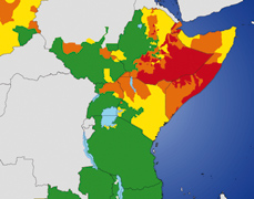 FEWS NET
 |
|
The map shows how FEWS NET estimated the conditions of food security in east Africa during the period July–September 2008. The data are partly derived from the UN/FAO GAUL system. The red areas are "extremely food insecure". Green means "generally food secure". |
One example of how ICT can help is the
Famine Early Warning System Network (FEWS NET). Its purpose is
to strengthen the ability of countries in Africa and Central
America, as well as Haiti and Afghanistan, to manage the risk of
food shortages by providing early signs of famine. Founded some
20 years ago, FEWS NET is funded by the United States Agency for
International Development (USAID) and works with international,
national, and regional partners.
The system works by using ICT to monitor
and analyse data relating to climate and weather, and their
impact on crops. The information is then presented to
decision-makers in the form of monthly food security updates,
forecasts and alerts, and support for emergency planning and
longer-term policy-making.
In cooperation with such agencies as the
National Oceanic and Atmospheric Administration (NOAA) in the
United States, FEWS covers environmental factors that affect
food security, including rainfall, vegetation and soil erosion.
Among its tools are data gathered via satellite, which allow
rainfall patterns to be estimated and the Normalized Difference
Vegetation Index (NDVI) to be compiled on the extent and health
of vegetation. Personnel on the ground travel through
agricultural areas to observe conditions and gather details of
production and marketing. They present regular reports to the
host country and international organizations.
The UNDP Human Development Report points
out that many developing countries lack the capacity and
resources to assess climate-related risks. For instance, there
is a severe lack of meteorological stations in sub-Saharan
Africa, where farmers depend on rain-fed agriculture. Much more
access to ICT is needed to help vulnerable regions adapt to
climate change.
Looking out for tsunami
There are several early warning systems
in place in areas of the world’s oceans that are vulnerable to
tsunami. Others are being developed, spurred by the terrible
consequences of the Indian Ocean tsunami in December 2004.
Various governments are cooperating in the creation of an
International Tsunami Information Centre, which at present is
hosted in Hawaii by NOAA. The tsunami warning systems use a
number of sensor systems developed for weather observation
(ocean buoys) and earthquake detection (seismic sensors). Once
collected, the data are fed, via satellite, into real-time
analysis and detection systems.
Emergency communications
After a disaster occurs, the faster that
Internet and telephone links can be provided to humanitarian
agencies in the field, the more lives will be saved.
Communications are essential for the effective planning and
provision of rescue and relief efforts. They also give victims a
chance to contact loved ones, and to receive and give
information and reassurance. ITU has provided equipment and
facilities for emergency communications following floods,
earthquakes and other natural disasters. For example, in May
2008 satellite terminals were sent to help relief operations in
two areas: Myanmar, hit by a devastating cyclone, and Sichuan
Province in China, which experienced a major earthquake.
Raising awareness
ICT are also crucial in raising
awareness of climate change, in educating people how to mitigate
it, and in building up human resources to adapt to its effects.
Local, national and international broadcasting by radio and
television are obvious ways in which information can be
disseminated. The Internet is also playing an increasingly
important role in schools and in adult training.
Among the initiatives that are
specifically targeted at this area are the online study
programmes of the Global Virtual University Consortium in
Education for Sustainable Development, in partnership with the
United Nations University. The UNU-GVU Consortium is an alliance
of universities that share knowledge on the topic, with a
particular focus on providing greater access to UN-related
educational and scientific resources. The aim is to create a
critical mass of people with the expertise to protect the
environment, especially in developing countries that are often
most vulnerable to the effects of climate change.
This kind of capacity development is
vital, since not all countries are able to take advantage of ICT
in responding to the challenges posed by climate change, while
also striving to achieve the Millennium Development Goals. There
is a clear need for a more comprehensive and integrated approach
— but ICT themselves can contribute. They provide a unique
opportunity to offer not only online education, but also the
tools for using our Earth’s limited resources more wisely.
|

