 George Burba
|
|
A research station in the Arctic
sends data via radio links |
Radiocommunications and climate change
Timely warning of impending
natural disasters, accurate climate prediction and detailed
understanding of the status of global water resources — these
are just some of the critically important challenges for the
global community. Radiocommunications are essential in answering
them all as we tackle the consequences of climate change.
The science of climate change has
benefited greatly from the parallel development of information
and communication technologies (ICT) in general, and radio
technologies in particular. The role of radiocommunications in
weather and climate monitoring is clearly shown, for example, in
the structure of the World Meteorological Organization’s Global
Observing System (GOS), which provides observations of the
atmosphere and the Earth’s surface, including oceans. It uses
remote sensing equipment placed on satellites, aircraft, and
radiosondes in weather balloons, the data from which are relayed
via radio links to environmental control centres.
Radio-based environmental monitoring
devices track the progress of hurricanes, typhoons, tornadoes,
thunderstorms, and the fumes from volcanoes and major forest
fires. Weather forecasts would be much less accurate without
radio systems collecting and processing meteorological data.
Satellite communications disseminate information to remote areas
and, of course, radio and television broadcasts are central in
warning the public about dangerous weather or environmental
events. Increasingly too, such information is being sent to
mobile phones and other wireless devices.
Measuring global warming
Remote sensors come in two types:
“passive” sensors record radiation being reflected by the object
under study. “Active” sensors transmit radio waves and measure
the reflected signal, as for example the radar altimeter
illustrated in Figure 1.
Gathered data are processed and analysed by computer. A
practical and very important example of remote sensing is in the
monitoring of global warming.
In order to promote countermeasures, it
is essential to monitor the state of global warming precisely,
and for this purpose it is necessary to observe the
concentration and increase or decrease in greenhouse gases (GHG)
throughout the world. Global monitoring of GHG is performed by
remote sensors on board satellites. These sensors can observe
the concentration and distribution of greenhouse gases, as well
as monitor their absorption and emission. A global satellite map
of carbon dioxide distribution, based on remote sensing data, is
shown in Figure 2. The launch of a
Japanese satellite dedicated to monitoring greenhouse gases in
Earth’s atmosphere was described in
ITU News of January–February 2009.
Increasing temperatures at the ocean
surface are among the factors governing violent storms,
hurricanes and rising sea levels. This is another area that is
being monitored by remote sensing from satellites. The surface
temperature of the sea can be measured to within an accuracy of
0.2°C (see Figure 3).
It is important to remember that the
radio-frequency bands used for remote sensing need to
incorporate the frequencies that are needed in monitoring
particular substances, such as water vapour or carbon dioxide
gas. The unalterable physical properties of each substance mean
that only specific frequencies can be used to detect them and
extract environmental information. This determines the choice of
spectrum that can be allocated for this purpose.
Adaptation and mitigation
|
ITU’s Radiocommunication
Sector (ITU–R) helps to combat climate change by:
- Allocating radio-frequency
spectrum and satellite orbits for climate monitoring and
emergency radiocommunication systems and applications
- Developing technical
standards (ITU–R Recommendations) and the treaty-status
Radio Regulations employed by these and other radio systems
- Developing worldwide and
regional plans to facilitate the introduction of
energy-efficient systems, and assisting in their
implementation
- Through its secretariat —
the Radiocommunication Bureau — managing international
spectrum and assisting ITU Member States in operating radio
systems effectively
- Facilitating the use of
radio systems to replace travel or the transport of goods
(“replacing atoms with bits”) and so reducing energy
consumption and GHG emissions across industry
- Providing guidance and
raising public awareness of the use of radio equipment and
systems for environmental protection.
For more information see
www.itu.int/ITU-R/index.asp?category=information&rlink=climate-change&lang=en
|
Adaptation to the adverse effects of
climate change is a key issue everywhere, but especially for
developing countries, which are often the most vulnerable and
the least equipped to protect their populations.
Radiocommunications themselves are contributing to the problem
of climate change because of the proliferation of wireless
devices (such as televisions, transmitters and mobile phones),
all of which need power and radiate heat. However,
radiocommunications, like other forms of ICT, can also do a
great deal to help. The main ways in which they do so are by:
- Mitigating greenhouse-gas emissions
from radio equipment, and helping other sectors to reduce
emissions through using, for instance, videoconferencing
- Providing environmental information
for building effective national and international mitigation
and adaptation strategies
- Developing systems for climate
monitoring, disaster prediction and detection, early warning
and disaster relief.
A good example of the mitigation of
greenhouse-gas emissions from radio systems can be seen in the
switchover from analogue to digital broadcasting. The use of
digital modulation means that transmitters need almost ten times
less power. Taking into account that there are hundreds of
thousands of transmitters around the world, some using up to
100–150 kW of electricity, the results can be very significant.
Moreover, the number of transmitters may be reduced due to the
possibility of transmitting up to ten television programmes over
a single 8 MHz channel, instead of one programme per channel.
Dealing with natural disasters
Disaster prediction and detection is an
important function of Earth exploration satellites, which also
provide the relevant data to emergency telecommunication systems
for distribution of early warnings. In addition, remote sensing
by satellite is used to monitor one of the most dangerous
consequences of climate change — rising sea levels that may
flood coasts worldwide, with some small island States facing
complete inundation. Figure 1 shows an example of a satellite
equipped with an altimeter for measuring sea levels. Modern
altimeters can identify a change in level with a precision of
two-to-three centimetres.
Radiocommunication systems are
especially important in disaster relief operations because, in
many cases, the wired telecommunication infrastructure is
damaged or destroyed by a disaster and only wireless systems can
be used (especially satellite and high-frequency terrestrial
systems). That is why deploying wireless communications is
typically among the first priorities in any emergency response,
rescue, and relief operation.
Satellite communications (see
Figure 4) can make a real difference during the first
crucial hours and days after a disaster. They are employed to
assess the extent of damage, help locate survivors, measure the
potential danger for rescue teams and ensure that humanitarian
response crews can communicate effectively with their team
members, other agencies, local hospitals and paramedics. And the
victims of a disaster, too, can contact rescuers and speak to
loved ones — all through the power of radiocommunications.
|
Figure 1 —
An altimeter on board a satellite monitors the sea level
|
|
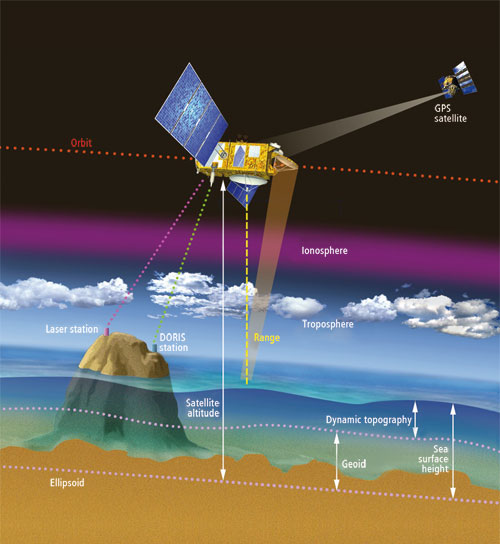
Source: CNES. |
|
|
Figure 2 — CO2 global map,
July 2008 — in parts per million by volume
|
|

Source: NASA. |
|
|
Figure 3 — Mediterranean sea surface temperature map, May 2006
|
|

Source: ESA. |
|
|
Figure 4 — satellite
system in a disaster relief operation
|
|

Source: ITU/Radiocommunication
Bureau. |
|
|

